What are best options for antenna, software, and other need to know information. What are the differences in software. What else will i need. Also are the laptop speeds needed to make it run efficiently?
GPS for Laptops. What options and Where to get?
- Thread starter draaronr
- Start date
You are using an out of date browser. It may not display this or other websites correctly.
You should upgrade or use an alternative browser.
You should upgrade or use an alternative browser.
Delorme: http://www.delorme.com/earthmate/ has some laptop GPS's.. they also have their Topo software.. I have yet to try it, but it looks pretty nice.. i currently have a palm m505 + magellean companion, and hardly use it at all.. i think i just need more memory, and to mount it someplace good. So thats a nice thing about the laptop, is you'll be able to fit all the maps on there without a problem.
I'd also be inclined to say that processor speed of your laptop isn't extremely important.. almost anything made within the last 5-6 years should be adequate to run the software.. just make sure you have a USB port or Bluetooth.
I'd also be inclined to say that processor speed of your laptop isn't extremely important.. almost anything made within the last 5-6 years should be adequate to run the software.. just make sure you have a USB port or Bluetooth.
If you have a a bluetooth card or enable laptop, I could make you a good deal on a socket bluetooth GPS Nav Kit
Any profit of course would have a 5% donation going to Discoweb.
Any profit of course would have a 5% donation going to Discoweb.
I recommend getting any standard GPS unit (I have the Garmin GPS V) and then hooking a laptop to it. I currently use the MapSource software that came with it for mapping and creating track logs. This way you can use any topo software you like. The benefit of having a stand alone unit is that you can use it without a laptop. I find it a nice to know how soon an exit is coming up on the highway. I use my GPS with a Dell laptop with a 15" screen. It works well, but the laptop is a bit big. I plan on replacing it with a small sony or Fujitsu with a 10" screen. It's just really uncomfortable if you have a passenger, so I don't use it if I have one.
Hope that helps a bit.
Jamil
Hope that helps a bit.
Jamil
I just really didn't want to have to go to the expense of the standalone unit. I see the antennaes on ebay for around $90 bucks all the time. What is good software to get if I go this route, I would use it mostly to offroad and get to these destinations.
W
wei
Guest
I am using the pole mounted Garmin GPS 17N antenna and built in receiver. The unit is connected to my laptop via a serial interface. For software, I am using the Garmin Mapsource software on a P4 1.8MHz Compaq laptop.
Prior to this, I had a Garmine eTrex Legend GPS unit connected to the same laptop. This setup didn't work for me because the GPS antenna didn't have a full view of the sky and kept losing satellites. The other problem with the Legend is the fact that I had to run 12V power to the unit from the cigarette lighter socket.
I prefer the GPS 17N much better. It was maintenance free and very straightforward to install.
A
AndrewClarke
Guest
I bought a new "GPS mouse" on eBay a couple months ago. Here it is although they sold it me for $63 for some reason: http://cgi.ebay.com/ws/eBayISAPI.dll?ViewItem&category=4668&item=5700012261 . It didn't come with any software to speak of, but it works fine and I'm happy with it. I then went into Best Buy to look at the software they were selling, and they had teh Delorme Earthmate WITH the Delorme software ($50 software, don't remember which one) for $90 after rebate. I don't know if they still have that deal going on but that's a really good deal.
The cool thing about the Delorme too is that it has a Bluetooth option so you can upgrade to that later if you feel like it.
Regarding software, I asked the same question when I got mine and didn't get any definitive responses right away. I bought two packages:
1. National Geographic Backroads Explorer. This is a good package. It comes with 1:100000 maps for the whole country and then you can buy 1:24,000 on a state-by-state basis. I don't have that yet. The nationwide package comes on 17 CDs which you can't seem to just install to the HD because of some lame copy protection scheme I guess but other than that it's full-featured and I like it.
2. Microsoft Streets & Trips 2004. I paid $20 after rebate for this so I figured why not. Welll, I'd have to say that it probably wasn't worth the $20. All the streets in my area seem to be shifted south by a few metres so it looks like I'm off-roading through peoples' houses when I'm driving down the road. Not a big annoyance but not great either. Also, it doesn't do voice prompts telling me where to turn, and it doesn't automatically re-route me when I miss a turn. Basically, it's a decent mapping app for $20, but the integration with a GPS seems like an afterthought. I should have kept the $20 and just put it towards "real" street mapping software which I'm still going to have to get anyway since the MS product doesn't cut it for me.
- Andrew.
What is your end use? Are you wanting to use it for getting from X location in City A to Y location in City B? Mostly on-road use? Or are you wanting to use it in conjunction with topography? Are you wanting to see your location on a topo map, recording routes of off-road trails that aren't on the maps? What kind of detail do you need? Do you need something on the order of what you would see on a 1:100,000 scale map? A 1:50,000 scale map? Or do you need something as detailed as a 1:24,000 scale map? Do you want to create your own maps? Do you want to use it over aerial photography? What's your budget? Do you want an easy-to-use interface, or can you handle using software that isn't intuitive?
I know, a helluva lot of questions. But there's a plethora of different ways to skin this cat: DeLorme, Fugawi, ESRI, Trimble, Garmin, Nat. Geo., Magellan, etc. etc., lots of different choices, depending on your needs. Lemme know what your goals/desires/limitations are, and I'll try to help.......
-L
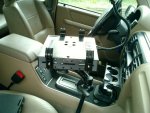
almost related to this thread...any good suggestions for how to mount a laptop efficiently in the car. I wouldn't be adverse to having my garmin hooked up to the laptop, but if the laptop is sitting on my passenger seat, it doesn't do me much good. Probably should have started a different thread....
W